
Design of an intelligent hyperspectral scanner for Drill-Core at the School of Surveying and Geospatial Engineering, University of Tehran
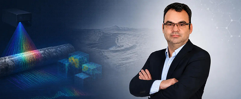
Dr. Mahdi Panahi, a researcher in the fields of remote sensing, artificial intelligence, and hyperspectral image analysis, and the inventor of the “Intelligent Hyperspectral Drill-Core Scanner,” has, according to the report of Stanford University, been continuously ranked among the world’s top two percent of scientists from 2022 to 2025. This technology is the result of his research collaboration with the University of Tehran within the framework of the Connect program, at the invitation of Dr. Mahdi Hasanlou, Dean of the School of Surveying and Geospatial Engineering.
The initial concept of this system took shape during this very collaboration, and Dr. Hasanlou’s guidance and support throughout all stages of its development played a decisive role in advancing the project. This collaboration provided the foundation for transferring international experience to the country’s technological needs. In this regard, the following interview was conducted with him.
How did the idea for this technology come about?
The idea for this technology arose from a real and long-standing need in the mining industry and geological studies. In many exploration projects, the examination of drill cores is still carried out based on visual observation, manual description, conventional photography, and the geologist’s experience. Although these methods are valuable, they are time-consuming, dependent on human interpretation, and limited in terms of reproducibility. On the other hand, important exploration decisions—from identifying alteration zones and selecting suitable samples for testing, to continuing or halting drilling and modeling the ore deposit—require data that are accurate, fast, standardized, and archivable. It was precisely this gap between industry needs and existing tools that led us toward developing a system capable of analyzing drill cores in a non-destructive, digital, automated, and data-driven manner.
How does this system work?
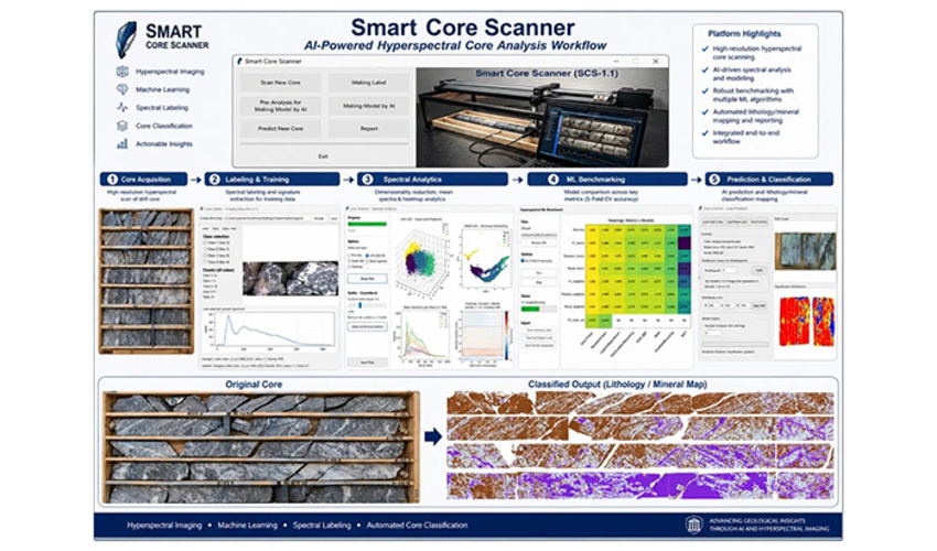
This system operates by integrating hyperspectral imaging, a precise motion mechanism, controlled illumination, and artificial intelligence algorithms. The drill cores are placed in a standard tray, and the hyperspectral camera scans their surface with high precision using a line-scan imaging method. The device’s output is not an ordinary image, but rather a hyperspectral data cube; this means that for each point on the core surface, in addition to spatial position, a unique spectral signature is recorded. This information enables the identification of lithology, mineralogy, alteration, oxidation, silicification, and textural changes.
In conventional methods, the quality of the results depends on the expert’s experience and the conditions under which the information is recorded. In this system, however, the data are acquired, stored, and processed uniformly and can always be re-analyzed. It also enables the creation of a digital archive of the cores, the comparison of samples across different time periods, and the direct linking of results to three-dimensional geological models.
What role does artificial intelligence play in this technology?
Artificial intelligence is the core of this system. After the hyperspectral data are acquired, preprocessing steps—including spectral correction, noise removal, normalization, and data preparation—are carried out. Machine learning and deep learning models then identify the spectral and textural patterns and automatically generate mineralogical and lithological maps.
In effect, artificial intelligence performs the same task that an experienced geologist does, but at a far greater speed, without fatigue, and with the ability to process thousands of data points simultaneously.
In the laboratory prototype, the accuracy of mineral identification has exceeded 85 percent, and with the completion of a spectral library of Iran’s native minerals and an increase in training data, improving this accuracy in the industrial version is achievable.
What are the applications of this technology?
This technology has broad applications in mining, oil and gas, and geological studies. In the mining sector, it can be used to identify promising zones, optimize sampling, reduce laboratory costs, and increase the accuracy of ore-deposit modeling. In the oil and gas industry, the system can perform the analysis of reservoir cores and the differentiation of facies with high accuracy and speed.
The most important impact of this technology is the reduction of uncertainty in exploration decision-making. When data are accurate, standardized, and comparable, decisions about whether to continue or halt drilling, where to sample, and how to prioritize exploration areas can be made with greater confidence.
What are the plans for the future?
As a first step, we are pursuing the official registration of the invention to protect the intellectual property of this achievement. At the same time, we have on our agenda the completion of a spectral library of Iran’s native minerals so that the artificial intelligence models can be trained on more realistic data and the system’s accuracy can reach the desired industrial level.
Our main goal is to develop a semi-industrial and then an industrial version of the device, and to expand collaboration with mining companies and organizations active in the field of exploration. Ultimately, we want to transform this technology from the laboratory stage into an intelligent decision-support tool for real mineral-exploration projects in the country—a tool that places Iran on the path of modern, data-driven exploration.
Closing remarks
This technology took shape at the intersection of international experience and local needs, and the University of Tehran was the platform for this synergy. We believe the future of the country’s mineral exploration will be built upon data, artificial intelligence, and modern technologies.
“The earth beneath our feet holds many secrets, and it is our duty to develop tools that reveal these secrets in the language of science and data. We hope this step will be a beginning for the development of indigenous technologies and the strengthening of the country’s technological independence in the field of earth sciences.”
Your Comment :